Interbay / Ballard
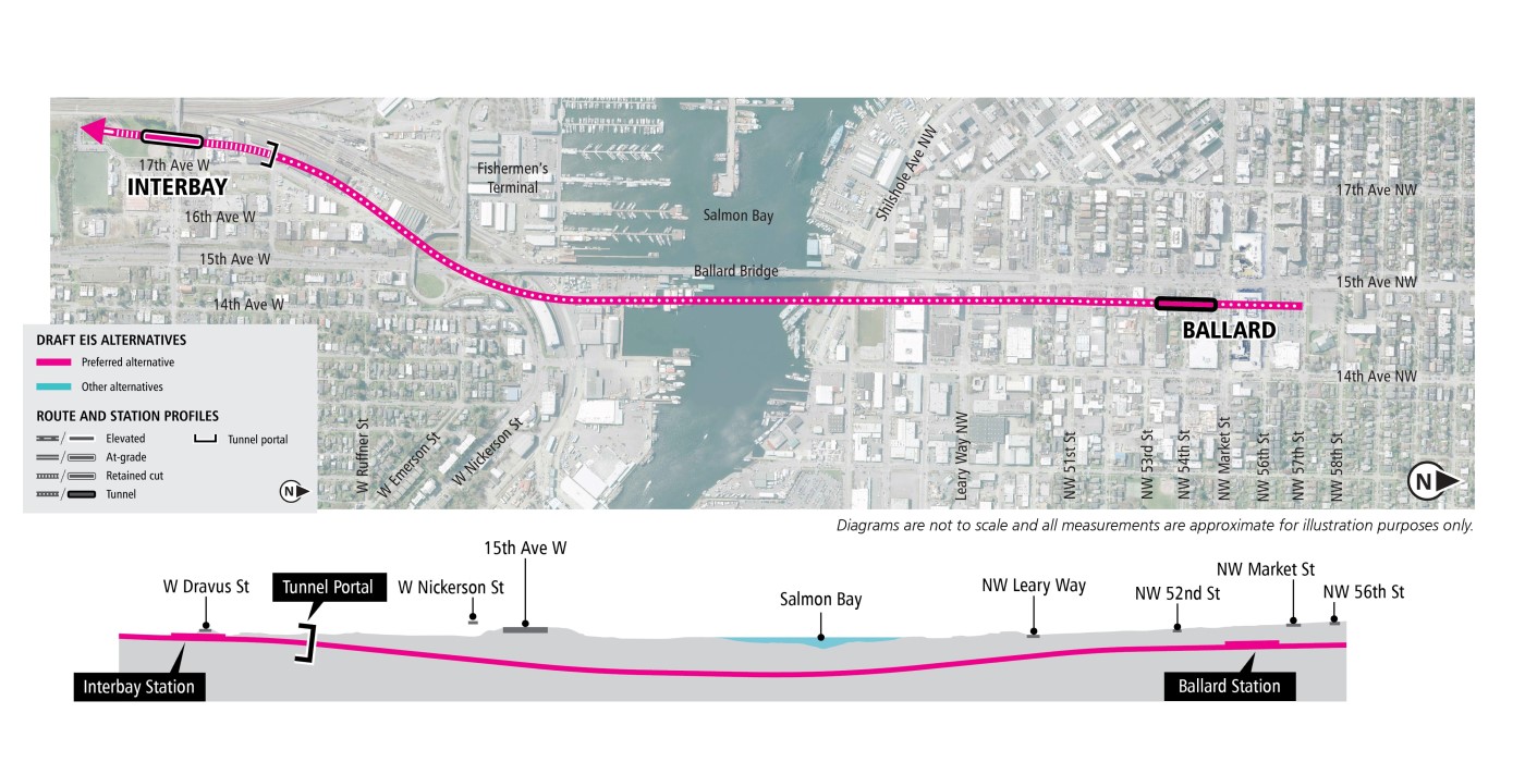
Preferred Alternative: Tunnel 15th Avenue
The alternative would begin at Interbay station straddling below West Dravus Street and continue in a retained cut to a tunnel portal traveling northeast under Salmon Bay (east of the Ballard Bridge), and then continue north in a tunnel east of 15th Avenue Northwest to the Ballard Station.
Station locations:
Interbay: The retained cut station at Interbay would be located through the Interbay Athletic Complex, below and straddling the existing West Dravus Street roadway bridge.
Ballard: The Ballard tunnel station would be east of 15th Avenue Northwest and south of Northwest Market Street.
Interbay/Ballard - other alternatives
The Tunnel 14th Avenue Alternative would enter a retained cut parallel to the BNSF tracks and then curve northeast to the Interbay Station. The alternative would continue in a retained cut from Interbay Station to a tunnel portal. The tunnel would travel northeast, under Salmon Bay (east of the Ballard Bridge), and then curve north beneath 14th Avenue Northwest to the Ballard Station.
Station locations:
Interbay: The retained cut Interbay station would be located north of West Dravus Street, between 17th Avenue West and Thorndyke Avenue West.
Ballard: The Ballard station would be located under 14th Avenue Northwest and Northwest Market Street.

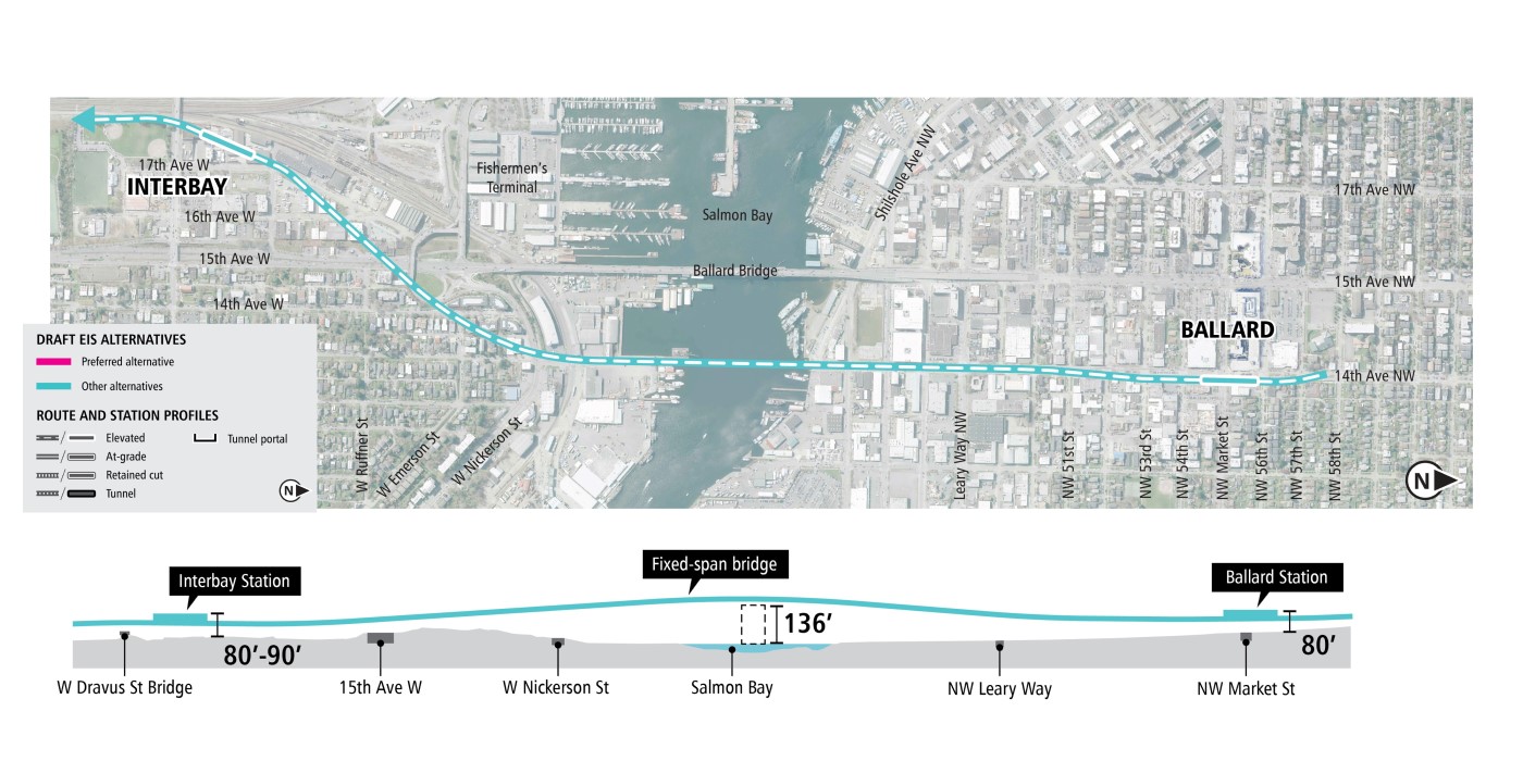
The Elevated 14th Avenue Alternative would travel parallel to the BNSF tracks over West Dravus Street and continue northeast to the Interbay Station. The alternative would continue elevated to a fixed-span bridge on the east side of the Ballard Bridge (15th Avenue Bridge). The alternative would continue north within 14th Avenue Northwest to the Ballard Station.
Station locations:
Interbay: The elevated Interbay Station would be located north of West Dravus Street between the railroad tracks and 17th Avenue West.
Ballard: The elevated Ballard station would be located on the east side of 14th Avenue Northwest, straddling Northwest Market Street.
The Elevated 14th Avenue (From Prospect Street Station/15th Avenue) Alternative is a design option for connecting the Prospect Street Station/15th Avenue Alternative in the South Interbay segment to the Elevated 14th Avenue Alternative bridge over Salmon Bay. The alignment would start south of the Interbay Station on 15th Avenue West. From the Interbay Station, the alternative would connect to the 14th Avenue alignment bridge over Salmon Bay. The bridge over Salmon Bay, the elevated guideway to the north, and the Ballard Station would be the same as for the Elevated 14th Avenue Alternative.
Station locations:
Interbay: The elevated Interbay Station would be located above 15th Avenue West, straddling West Dravus Street.
Ballard: The elevated Ballard station would be located on the east side of 14th Avenue Northwest, straddling Northwest Market Street.

The Elevated 15th Avenue Alternative would be in the median of 15th Avenue West approaching the Interbay Station. From the station, the alternative would continue on an elevated guideway and cross Salmon Bay on a moveable bridge west of the Ballard Bridge. The alternative would continue north from the bridge on an elevated guideway to the Ballard Station.
Station locations:
Interbay: The elevated Interbay Station would be located above 15th Avenue West, straddling West Dravus Street.
Ballard: The elevated Ballard station would be located above the east edge of 15th Avenue Northwest, south of Northwest Market Street.

The alternatives presented were developed through years of planning and community engagement. To learn more about the alternatives raised but not carried forward for study in the Draft EIS, see the Further Studies: Community Engagement Summary (2023), and Appendix M from the previous WSLE Draft EIS.