Chinatown-International District/SODO (CID/SODO)

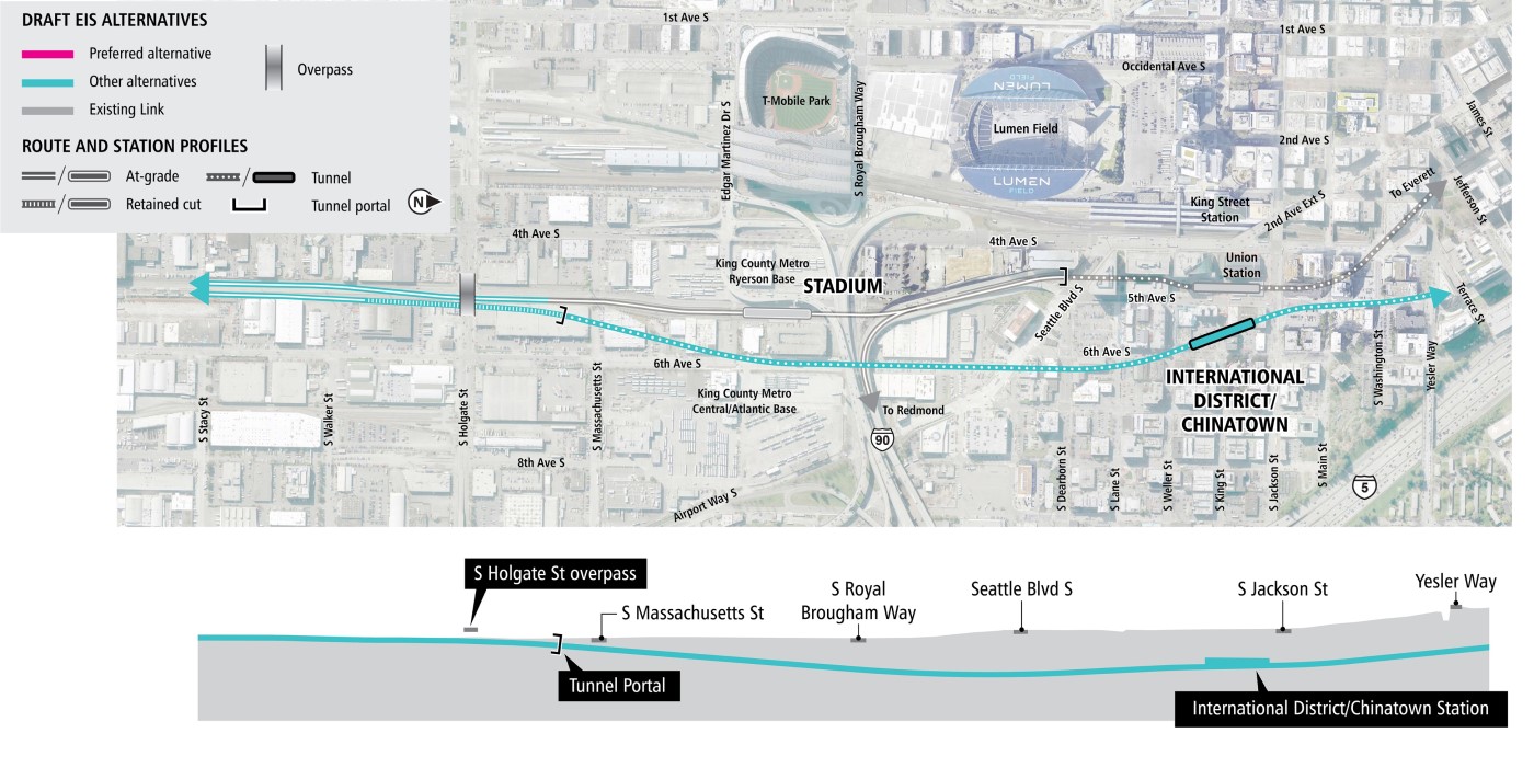
Preferred Alternative: Dearborn Street

The Dearborn Street Alternative would begin north of the SODO station and continue east of the existing Link light rail line and extend north. The alternative would then enter a tunnel heading north beneath 6th Avenue. The tunnel alignment would continue north beneath 6th Avenue South to South Jackson Street and then transition to continue northwest passing under 5th Avenue South.

Station location: The station would be located beneath 6th Avenue South, straddling Seattle Boulevard South.

Map of the Chinatown-International District/SODO segment from South Stacy Street to Yesler Way centered around 6th Avenue South. Shows profile view of the tunnel station.
Diagrams are not to scale and all measurements are approximate for illustration purposes only. | Click on image to enlarge

Chinatown-International District/SODO - other alternatives

The 4th Avenue Shallow Alternative would begin north of the SODO station and continue east of the existing Link light rail line and extend north. The alternative would then enter a tunnel and continue northwest and then north under 4th Avenue. This alternative would necessitate reconstruction of the existing Stadium Station.

Station location: The station would be located beneath 4th Avenue South, west of and with underground pedestrian connection to the existing International District/Chinatown Station.

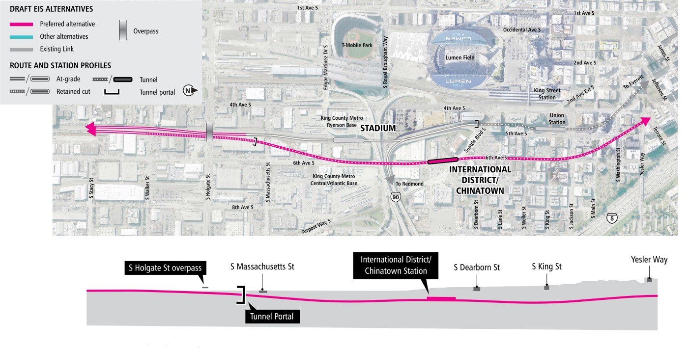
Map of the Chinatown-International District/SODO segment from South Stacy Street to Yesler Way centered around 4th Avenue South. Shows profile view of the tunnel station.
Diagrams are not to scale and all measurements are approximate for illustration purposes only. | Click on image to enlarge

The 4th Avenue Shallower Alternative would be the same as the 4th Avenue Shallow Alternative, except it would be shallower in the station area and north of the station. This alternative would necessitate reconstruction of the existing Stadium Station

Station location: The station would be located beneath 4th Avenue South, west of and with underground pedestrian connection to the existing International District/Chinatown Station.
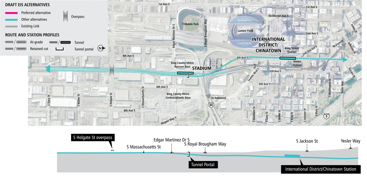
Map of the Chinatown-International District/SODO segment from South Stacy Street to Yesler Way centered around 4th Avenue South. Shows profile view of the tunnel station.
Diagrams are not to scale and all measurements are approximate for illustration purposes only. | Click on image to enlarge

The 4th Avenue Deep Alternative would begin north of the SODO station and continue east of the existing Link light rail line and extend north. The alternative would then enter a tunnel heading northwest to continue north beneath 4th Avenue South with a deep tunnel and station.

Station location: The station would be located beneath 4th Avenue South, west of and with underground pedestrian connection to the existing International District/Chinatown Station.
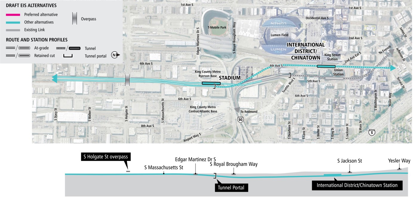
Map of the Chinatown-International District/SODO segment from South Stacy Street to Yesler Way centered around 4th Avenue South. Shows profile view of the tunnel station.
Diagrams are not to scale and all measurements are approximate for illustration purposes only. | Click on image to enlarge

The 5th Avenue Shallow Alternative would begin north of the SODO station and continue east of the existing Link light rail line and extend north. The alternative would then enter a tunnel heading north beneath 6th Avenue and then transition to under 5th Avenue South.

Station location: The station would be located beneath 5th Avenue South, east of and with underground pedestrian connection to the existing International District/Chinatown Station.
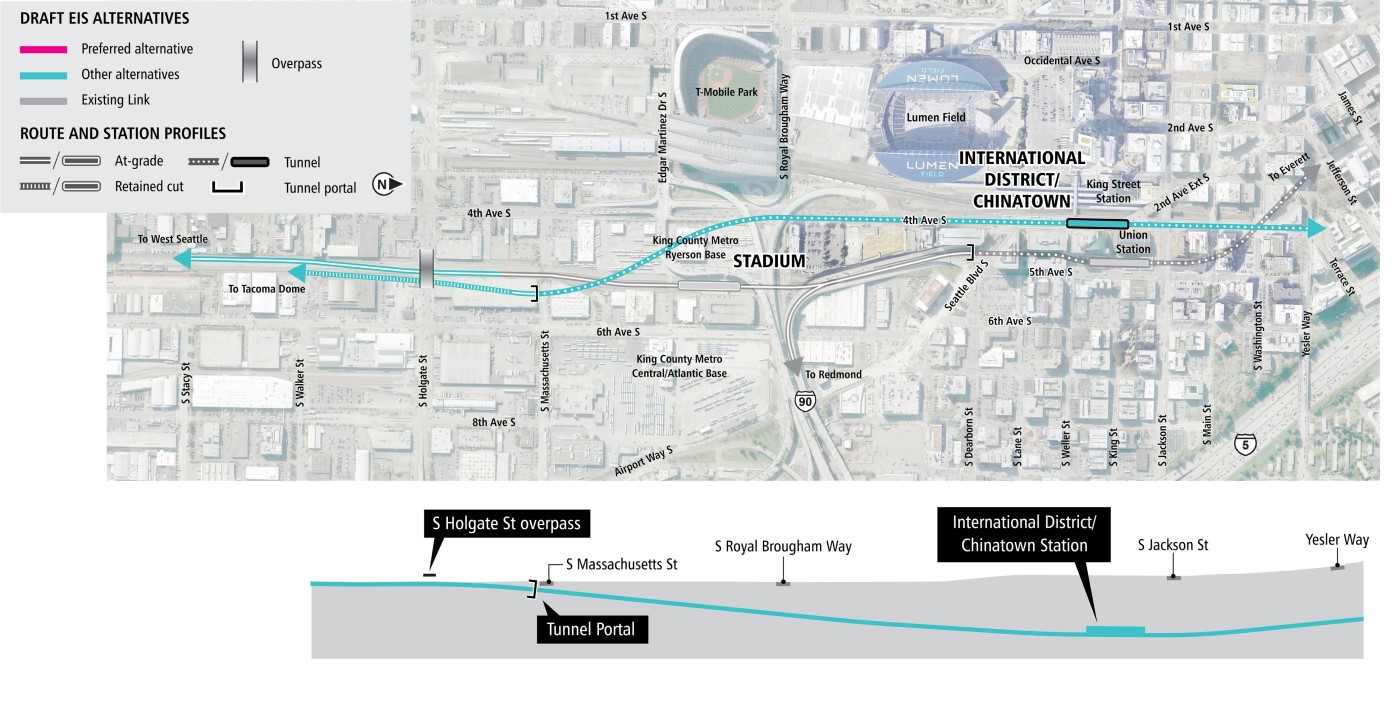
Map of the Chinatown-International District/SODO segment from South Stacy Street to Yesler Way centered around 5th Avenue South. Shows profile view of the tunnel station.
Diagrams are not to scale and all measurements are approximate for illustration purposes only. | Click on image to enlarge

The 5th Avenue Deep Alternative would generally follow the same route as the 5th Avenue Shallow Alternative, except that the tunnel and the station would be deeper.

Station location: The station would be located beneath 5th Avenue South, east of and with underground pedestrian connection to the existing International District/Chinatown Station.
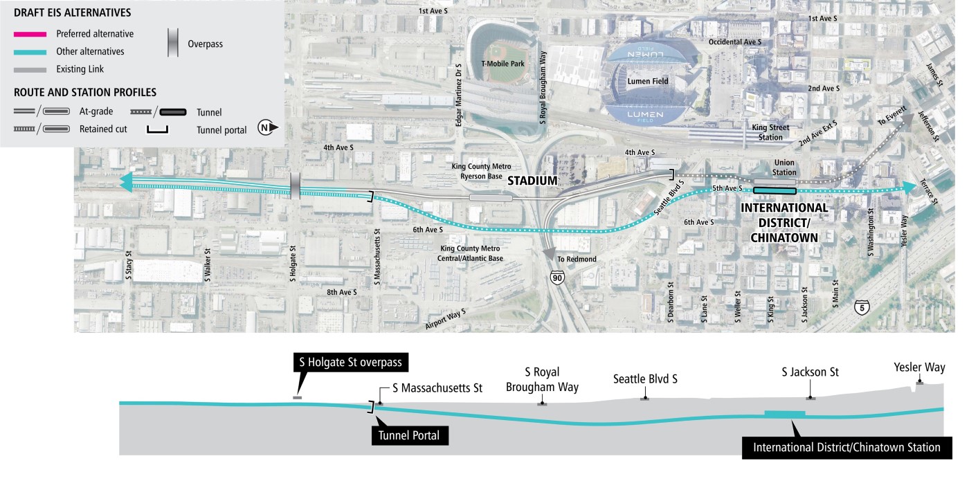
Map of the Chinatown-International District/SODO segment from South Stacy Street to Yesler Way centered around 5th Avenue South. Shows profile view of the tunnel station.
Diagrams are not to scale and all measurements are approximate for illustration purposes only. | Click on image to enlarge

The 5th Avenue Shallow Diagonal Alternative would be the same as the 5th Avenue Shallow Alternative except that it would transition towards 5th Avenue South further north of Seattle Boulevard South.

Station location: The station would be located beneath the area between 5th Avenue South and 6th Avenue South, east of and with underground pedestrian connection to the existing International District/Chinatown Station.
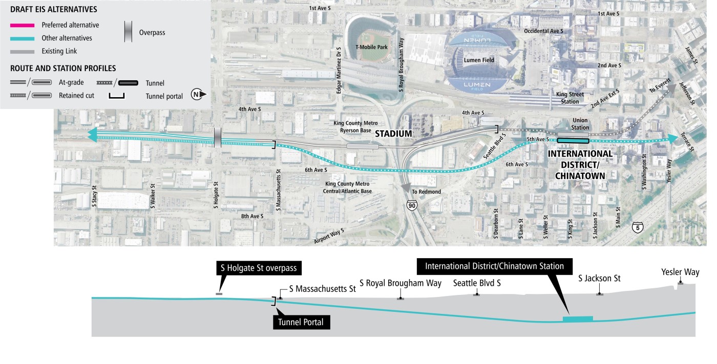
Map of the Chinatown-International District/SODO segment from South Stacy Street to Yesler Way centered around 5th Avenue South. Shows profile view of the tunnel station.
Diagrams are not to scale and all measurements are approximate for illustration purposes only. | Click on image to enlarge

The alternatives presented were developed through years of planning and community engagement. To learn more about the alternatives raised but not carried forward for study in the Draft EIS, see the Further Studies: Community Engagement Summary (2023), and Appendix M from the previous WSLE Draft EIS.